Overview
On May 31, 2013, a significant tornado outbreak impacted central Oklahoma, characterized by a complex, long-track tornado that moved through Canadian County near El Reno. The event was part of a larger severe weather episode that included multiple tornadoes, damaging thunderstorm winds, large hail, and catastrophic flash flooding in the Oklahoma City metropolitan area. The El Reno tornado, which reached a maximum width of 2.6 miles, resulted in 13 direct fatalities and 35 injuries across the region.
Environmental Context
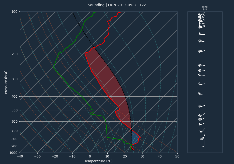
The atmospheric environment on May 31, 2013, was highly favorable for the development of intense supercells. The pre-event sounding from OUN indicated significant instability with a CAPE of 3342 J/kg and a CIN of -134 J/kg, suggesting that while a cap was present, the atmosphere was primed for explosive convective initiation. The 0-6km bulk shear of 42 knots provided the necessary kinematic support for sustained supercell structures.
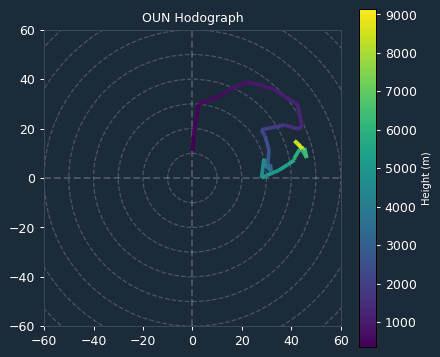
The storm-time environment, as derived from the VAD wind profile, showed extreme values for Storm Relative Helicity (SRH). The 0-1km SRH was 576 m²/s², and the 0-3km SRH was 553 m²/s². These exceptionally high values indicate a highly supportive environment for intense mesocyclone development and significant tornado potential, providing the necessary low-level rotation to sustain the violent nature of the El Reno tornado.
Storm Evolution
The El Reno tornado developed at 6:03 p.m. CST (23:03 UTC) just northeast of the intersection of Heaston and Reuter roads. Initially moving southeast at 20 to 25 mph, the tornado turned east at 6:09 p.m. and expanded rapidly in size near the El Reno Municipal Air Park. As it crossed Highway 81 at 6:19 p.m., the tornado turned north and accelerated to over 50 mph. Between 6:24 p.m. and 6:26 p.m., it reached its maximum size and intensity. The circulation then slowed to less than 10 mph as it performed a loop north of I-40, eventually dissipating at 6:42 p.m. near the intersection of I-40 and Banner Road.
Radar analysis from KTLX confirms the intensity of the parent supercell. Throughout the event, the maximum inbound and outbound velocities remained locked at 64.1 knots, indicating that the mesocyclone rotation consistently exceeded the radar's maximum unambiguous velocity threshold (the Nyquist limit). High-reflectivity cores were observed descending toward the surface, with maximum reflectivity values frequently exceeding 70 dBZ, consistent with the presence of large hail and intense tornadic debris.
Warnings Issued
A total of four warnings were issued by the National Weather Service in Norman (OUN) for the event. The first tornado warning (OUN.TO.W.0057) was issued at 10:36 p.m. UTC (5:36 p.m. CST), providing 27 minutes of lead time before the tornado touched down at 6:03 p.m. CST. This lead time significantly exceeded the national average of approximately 13 minutes, demonstrating high warning effectiveness for this event.
Impacts
The El Reno tornado was rated EF3 based on ground damage surveys. While mobile radar data from the University of Oklahoma RaXPol and the Center for Severe Weather Research’s Doppler on Wheels measured winds exceeding 200 mph—with at least 295 mph detected in small sub-vortices—these intense features did not impact structures, limiting the official EF rating. The tornado caused extensive damage to homes and businesses, and destroyed crops in rural Canadian County. Tragically, all eight fatalities associated with this specific tornado occurred in vehicles, including three severe storm researchers.
Beyond the primary tornado, the broader episode included an EF1 tornado in Oklahoma County that injured eight people, and an EF2 anticyclonic tornado southwest of Yukon. Flash flooding in Oklahoma City, which lasted into the overnight hours, resulted in five additional fatalities as individuals were swept away in floodwaters. Widespread wind damage was also reported across southwest Oklahoma City, with wind gusts measured at 70 mph and 71 mph at Will Rogers World Airport.
Conclusion
The May 31, 2013, event was a complex and dangerous weather situation. The combination of extreme SRH values and significant instability facilitated the development of a violent, long-track tornado and a subsequent flash flood event that caused significant loss of life and property damage. Despite the challenges posed by the tornado's rapid changes in speed and direction, the 27-minute lead time provided by the initial tornado warning offered a critical window for public safety.