Overview
On May 20, 2013, a violent tornado outbreak impacted central Oklahoma, resulting in catastrophic damage across McClain and Cleveland Counties. The most significant event of the day was a long-track, violent tornado that moved through Newcastle, Moore, and south Oklahoma City. This system resulted in 24 direct fatalities and 212 direct injuries. The tornado was officially rated as an EF5, with a total path length of 13.8 miles across the affected counties.
Environmental Context
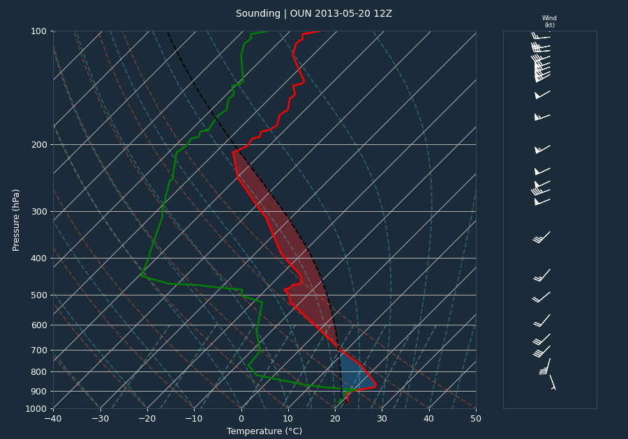
The pre-event sounding from OUN at 12:00 UTC indicated a moderately unstable environment with 1,811 J/kg of CAPE and a CIN value of -271 J/kg, suggesting a capped atmosphere that required significant forcing for convective initiation. The 0-6km bulk shear of 46 knots provided a favorable environment for supercell development. It should be noted that these sounding values likely under-sample the instability present in the warm sector at the time of the event, as the storm environment became increasingly primed for tornadogenesis.
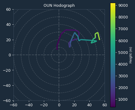
Kinematic data derived from the VAD wind profile at the time of the event showed significant potential for rotation. The 0-1km Storm Relative Helicity (SRH) was 310 m²/s², and the 0-3km SRH was 302 m²/s². These high SRH values were critical in supporting intense mesocyclone development and provided the necessary low-level shear for the production of a violent, long-track tornado.
Storm Evolution
Radar analysis from KTLX indicates that the storm exhibited extreme rotational intensity throughout its lifecycle. Beginning at 19:46 UTC, the radar observed a strong velocity couplet. The inbound and outbound velocities consistently reached 64.1 knots, which saturated the radar's measurement capabilities, indicating that actual rotational winds were significantly higher than the instrument could record. Reflectivity values were consistently high, frequently reaching 75 dBZ. A notable trend in the radar data was the descent of the maximum reflectivity core; by 19:59 UTC, the height of the maximum reflectivity dropped to 16.8 kft, and it remained at or below this level through 20:38 UTC. This core descent, coupled with sustained high reflectivity and saturated velocity measurements, confirms the maintenance of a violent, debris-rich tornadic circulation as it moved through the Moore metropolitan area.
Warnings Issued
A total of six warnings were issued by the National Weather Service in Norman (WFO OUN) during the event, including three Tornado Warnings and three Severe Thunderstorm Warnings. The first tornado warning (OUN.TO.W.0024) was issued at 19:40 UTC, while the EF5 tornado touched down at 20:04 UTC. This provided a lead time of 24 minutes, which significantly exceeded the national average lead time of approximately 13 minutes, allowing for critical public notification prior to the tornado's arrival in populated areas.
Impacts
The tornado caused widespread, catastrophic destruction. In McClain County, the tornado began near Newcastle, where it produced EF4 damage. As it crossed into Cleveland County, the tornado intensified, reaching EF5 status. The path through Moore included the destruction of Briarwood Elementary School and Plaza Towers Elementary School. Despite the total destruction of these facilities during school hours, no fatalities occurred at Briarwood Elementary, though seven children were killed at Plaza Towers Elementary. The tornado also caused significant damage to the Moore Medical Center and numerous businesses along Interstate 35. Over 300 homes experienced EF4 or EF5 damage. Of the 212 direct injuries, 207 occurred in Cleveland County. Property damage estimates for the Cleveland County segment alone reached $2,000,000,000.00.
Conclusion
The May 20, 2013, event was a high-impact, violent tornado outbreak characterized by extreme low-level shear and a highly unstable environment. The combination of early warning lead times and the extreme intensity of the tornado resulted in a significant loss of life and massive property destruction across the Moore and south Oklahoma City corridor. The event remains a notable example of a violent, long-track supercell tornado in a high-shear, moderate-instability regime.