SWX
Severe Weather Event Reporter
EVENT REPORT ENDERLIN, RANSOM COUNTY, NORTH DAKOTA, UNITED STATES

ENDERLIN TORNADO

June 20, 2025

The event narrative is AI-generated from structured meteorological data and may contain errors. Verify critical facts against the NCEI, NWS, and LSR data sections below.

IMPACT SUMMARY
EF Rating
EF5
confirmed
Warning Lead Time
22 min
before touchdown
Fatalities
3
direct deaths (tornadoes)
Path Length
12.2
mi (DAT surveyed)
Max Reflectivity
69.0
dBZ
Echo Tops
69.8
kft (18 dBZ)
Warnings
10
NWS issued
Storm Reports
34
LSRs filed
PRE-EVENT SOUNDING & VAD WINDS ABR 2025-06-21

Skew-T Log-P

Pre-event sounding

Ambient Hodograph (Event-Time)

Ambient Hodograph
CAPE
4692
J/kg
CIN
-41
J/kg
0-6km Shear
49
knots
Sfc Temp
34.0
°C
Sfc Dewpoint
22.0
°C
Sfc Pressure
950.0
hPa
0-1km SRH
186
m²/s²
0-3km SRH
347
m²/s²

Skew-T: nearest pre-event balloon launch from ABR - Source: IEM RAOB Archive / University of Wyoming. Hodograph derived from VAD winds extracted from event-time radar velocity data.

EVENT NARRATIVE

Overview

On the evening of June 20, 2025, and into the early morning hours of June 21, 2025, a significant severe weather outbreak impacted southeast North Dakota. The event was characterized by the development of supercell thunderstorms that produced multiple tornadoes, including a violent EF5, followed by a powerful derecho that brought widespread straight-line wind damage across the region. The episode resulted in three direct fatalities and caused extensive agricultural damage, with state officials estimating a loss of 50 to 80 million bushels of grain storage capacity.

Environmental Context

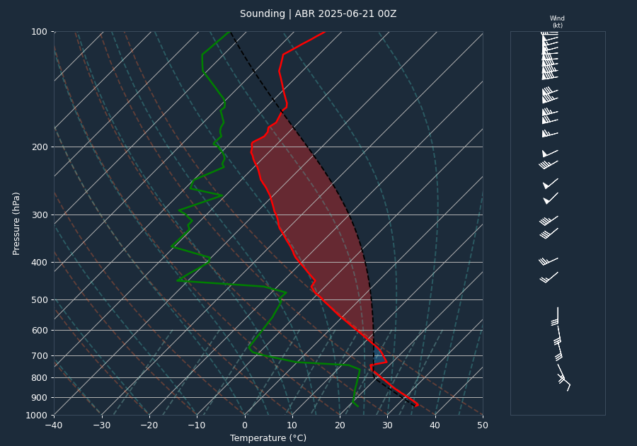
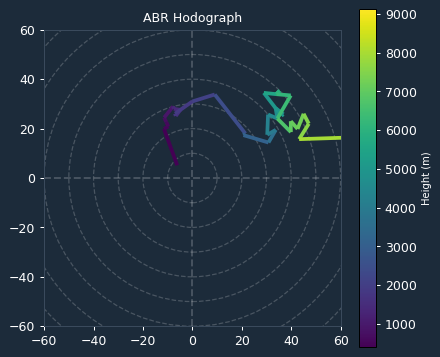
The atmospheric environment was highly primed for severe weather. A pre-event sounding from Aberdeen, South Dakota, indicated extreme instability with a CAPE value of 4692 J/kg and a CIN of -41 J/kg, suggesting a volatile atmosphere with minimal inhibition for convective initiation. The 0-6km bulk shear of 49 knots provided a favorable environment for supercell development.

Kinematic data derived from the VAD wind profile at the time of the event further highlighted the potential for tornadogenesis. The 0-1km Storm Relative Helicity (SRH) was 186 m²/s², while the 0-3km SRH reached 347 m²/s². These significant SRH values indicate strong low-level wind shear, which played a critical role in supporting mesocyclone development and the production of intense, long-track tornadoes.

Storm Evolution

Radar analysis from KMVX tracked the evolution of the supercell storms. Throughout the event, maximum reflectivity values frequently exceeded 67 dBZ. A notable trend in the radar data was the descent of the high-reflectivity core; for instance, the height of maximum reflectivity dropped from 19.9 kft at 04:27:42 UTC to 4.8 kft by 04:20:49 UTC, often signaling the intensification of the storm's low-level structure. Inbound and outbound velocities consistently reached 65.1 knots, which represented the effective measurement limit (Nyquist) of the radar, indicating intense rotation within the storm's core.

Warnings Issued

A total of 10 warnings were issued by the National Weather Service in Grand Forks (FGF) to address the evolving threat. These included multiple tornado warnings and severe thunderstorm warnings as the system transitioned from discrete supercells to a derecho.

Warning effectiveness was high, particularly regarding the most significant tornado of the event. The first tornado warning for the Enderlin area was issued at 03:42:00 UTC, providing 22 minutes of lead time before the EF5 tornado touched down at 04:04:00 UTC. This lead time significantly exceeded the national average of approximately 13 minutes, providing critical time for public awareness.

Impacts

The event produced 17 verified tornado records across the region. The most destructive was the Enderlin #1 tornado, which tracked 12.097 miles with a maximum width of 1850 yards. This EF5 tornado resulted in three direct fatalities. Forensic analysis of a train derailment south of Highway 46, where 33 train cars were tipped or lofted, confirmed wind speeds exceeding 210 mph. The tornado caused catastrophic damage to multiple farmsteads, including leveled homes and debarked trees.

Other significant tornadoes included an EF3 in Barnes County that destroyed metal buildings and lofted vehicles, and an EF2 near Valley City that caused extensive structural damage. In addition to the tornadoes, the subsequent derecho produced widespread straight-line wind damage. Notable wind gusts included 111 mph near Luverne, 99 mph near Galesburg, and 95 mph near Dazey. The combination of these events led to widespread destruction of grain storage facilities and infrastructure across Barnes, Cass, Ransom, and Steele counties.

Conclusion

The June 20-21, 2025, severe weather event was a historic episode for southeast North Dakota. The combination of extreme instability and significant low-level shear facilitated the production of violent tornadoes, including an EF5, followed by a destructive derecho. While the event resulted in three fatalities, the effective warning lead times provided by the National Weather Service were instrumental in the public response during this high-impact weather scenario.

EVENT MAP

Tornado Warning Severe Thunderstorm Warning Tornado Track (DAT/NCEI) LSR

Disclaimer: Tornado tracks use NWS DAT surveyed geometry when available, otherwise NCEI start/end coordinates as straight lines. Actual paths may curve. Width corridors are based on maximum reported width and are approximate.
RADAR LOOP 7 FRAMES
FRAME 01 OF 07 2025-06-21T03:48:00
Base Reflectivity & Velocity (0.5°) - Click image to view all frames
VOLUME SCAN ANALYSIS 7 VOLUMES
Time (UTC) Max dBZ Max Z (kft) 18 Top 50 Top Vel In Vel Out
2025-06-21T03:48:00 68.5 9.7 69.8 51.6 -65.1 65.1
2025-06-21T03:54:53 68.5 12.5 69.7 51.1 -65.1 65.1
2025-06-21T04:01:44 67.5 15.0 69.5 52.0 -65.1 65.1
2025-06-21T04:08:03 67.5 8.8 69.7 52.3 -65.1 65.1
2025-06-21T04:14:31 69.0 25.8 68.1 53.4 -65.1 65.1
2025-06-21T04:20:49 67.0 4.8 65.3 47.4 -65.1 65.1
2025-06-21T04:27:42 68.5 19.9 68.6 48.3 -65.1 65.1
ACTIVE WARNINGS 10 ISSUED
Tornado Warning
Issued: 2025-06-21T02:58:00Z
Expires: 2025-06-21T03:45:00Z
Barnes [ND], Ransom [ND]
Severe Thunderstorm Warning
Issued: 2025-06-21T03:41:00Z
Expires: 2025-06-21T04:45:00Z
Cass [ND], Ransom [ND], Barnes [ND]
Tornado Warning
Issued: 2025-06-21T03:42:00Z
Expires: 2025-06-21T04:30:00Z
Cass [ND], Ransom [ND], Barnes [ND]
Severe Thunderstorm Warning
Issued: 2025-06-21T04:24:00Z
Expires: 2025-06-21T05:00:00Z
Ransom [ND], Cass [ND], Barnes [ND], Richland [ND]
Tornado Warning
Issued: 2025-06-21T04:25:00Z
Expires: 2025-06-21T05:00:00Z
Cass [ND], Ransom [ND], Richland [ND]
Tornado Warning
Issued: 2025-06-21T02:56:00Z
Expires: 2025-06-21T03:45:00Z
Barnes [ND], Cass [ND]
Severe Thunderstorm Warning
Issued: 2025-06-21T04:17:00Z
Expires: 2025-06-21T05:00:00Z
Barnes [ND], Traill [ND], Steele [ND], Nelson [ND], Grand Forks [ND], Cass [ND]
Tornado Warning
Issued: 2025-06-21T04:20:00Z
Expires: 2025-06-21T04:45:00Z
Barnes [ND], Cass [ND]
Severe Thunderstorm Warning
Issued: 2025-06-21T03:37:00Z
Expires: 2025-06-21T04:30:00Z
Barnes [ND], Griggs [ND], Steele [ND]
Severe Thunderstorm Warning
Issued: 2025-06-21T04:29:00Z
Expires: 2025-06-21T05:30:00Z
Benson [ND], Barnes [ND], Steele [ND], Nelson [ND], Griggs [ND], Eddy [ND]
LOCAL STORM REPORTS 34 REPORTS
04:14 UTC (11:14 PM CDT) TSTM WND DMG Valley City

Tree branches 6 inches to 10 inches in diameter were reported down in Valley City.

07:00 UTC (2:00 AM CDT) TSTM WND DMG 3 NW Buffalo

Corrects previous tstm wnd dmg report from 3 NW Buffalo. Upstream and downstream obs ranged from 55 to 95 mph at the time. Tree damage found during damage surveys.

06:25 UTC (1:25 AM CDT) TSTM WND DMG 3 NW Buffalo

Upstream and downstream obs ranged from 55 to 95 mph at the time. Tree damage found during damage surveys.

04:50 UTC (11:50 PM CDT) TSTM WND GST 50 2 SSW Barrie

Mesonet station 322589 Ekre ND NDAWN.

06:23 UTC (1:23 AM CDT) TSTM WND GST 54 5 NNE Kathryn

Mesonet station 322959 Fingal ND NDAWN.

04:41 UTC (11:41 PM CDT) TSTM WND GST 57 6 N Leonard

Corrects time of previous tstm wnd gst report from 6 N Leonard. Mesonet station 324969 Leonard ND NDAWN.

04:45 UTC (11:45 PM CDT) TSTM WND GST 57 6 N Leonard

Mesonet station 324969 Leonard ND NDAWN.

04:45 UTC (11:45 PM CDT) TSTM WND GST 59 5 E Amenia

Corrects previous non-tstm wnd gst report from 5 E Amenia. Mesonet station 327359 Prosper ND NDAWN.

04:42 UTC (11:42 PM CDT) TSTM WND GST 67 5 E Amenia

Corrects previous tstm wnd gst report from 5 E Amenia. 10 meter gust from mesonet station 327359 Prosper ND NDAWN.

04:48 UTC (11:48 PM CDT) TSTM WND GST 79 1 S Gardner

NDAWN 3 meter measurement.

05:49 UTC (12:49 AM CDT) TSTM WND GST 80 Valley City

Wind gusts of 70 mph - 80 mph and power flashes were reported on social media.

06:10 UTC (1:10 AM CDT) TSTM WND GST 81 1 N Pillsbury

Corrects previous non-tstm wnd gst report from 1 N Pillsbury. Mesonet station 327049 Pillsbury ND NDAWN.

05:42 UTC (12:42 AM CDT) TSTM WND GST 88 1 N Pillsbury

Corrects previous tstm wnd gst report from 1 N Pillsbury. Mesonet station 327049 Pillsbury ND NDAWN.

05:06 UTC (12:06 AM CDT) TSTM WND GST 90 Leonard

Corrects previous tstm wnd gst report from Leonard. Reports of estimated 90mph winds via storm chaser on X, possibly associated with a tornado.

06:30 UTC (1:30 AM CDT) TSTM WND GST 90 4 W Hunter

Personal weather station via Weather Underground, I.D. Richtsmeier HU20 - KNDHUNTE4. Measured gust to 90 mph. Highest sustained wind 66 mph. Duration of severe gusts unknown due to power outage right after initial gust. Extreme wind gusts associated with MCV on backside of derecho.

05:50 UTC (12:50 AM CDT) TSTM WND GST 95 3 E Dazey

Corrects previous non-tstm wnd gst report from 3 E Dazey. Mesonet station 321999 Dazey ND NDAWN.

05:45 UTC (12:45 AM CDT) TSTM WND GST 95 3 E Dazey

Corrects time of previous tstm wnd gst report from 3 E Dazey. Mesonet station 321999 Dazey ND NDAWN.

06:34 UTC (1:34 AM CDT) TSTM WND GST 96 Ayr

NDAWN 10 meter measurement.

06:30 UTC (1:30 AM CDT) TSTM WND GST 99 4 SSW Galesburg

Corrects previous non-tstm wnd gst report from 4 SSW Galesburg. Mesonet station 323359 Galesburg ND NDAWN.

06:26 UTC (1:26 AM CDT) TSTM WND GST 99 4 SSW Galesburg

Corrects time of previous tstm wnd gst report from 4 SSW Galesburg. Mesonet station 323359 Galesburg ND NDAWN.

05:40 UTC (12:40 AM CDT) TSTM WND GST 111 1 E Luverne

Corrects previous tstm wnd gst report from 1 E Luverne. 111 mph maximum gust recorded by personal weather station.

04:31 UTC (11:31 PM CDT) HAIL 1 Chaffee
04:45 UTC (11:45 PM CDT) NON-TSTM WND GST 59 5 E Amenia

Mesonet station 327359 Prosper ND NDAWN.

05:50 UTC (12:50 AM CDT) NON-TSTM WND GST 95 3 E Dazey

Mesonet station 321999 Dazey ND NDAWN.

06:30 UTC (1:30 AM CDT) NON-TSTM WND GST 99 4 SSW Galesburg

Mesonet station 323359 Galesburg ND NDAWN.

12:00 UTC (7:00 AM CDT) RAIN 1.18 5 SSW Casselton

Cocorahs station ND-CS-32 Durbin ND 5.4 WNW.

13:00 UTC (8:00 AM CDT) RAIN 2.21 5 NNE Leonard

Cocorahs station ND-CS-62 Leonard ND 4.7 NNE.

02:58 UTC (9:58 PM CDT) TORNADO 2 W Valley City

A tornado was reported 2 miles west of Valley City.

04:50 UTC (11:50 PM CDT) TORNADO Davenport

Delayed report: A funnel cloud was reported in Davenport with possible touchdown.

04:11 UTC (11:11 PM CDT) TORNADO 3 E Enderlin

There were reports of home damage east/northeast of Enderlin. Time estimated via radar.

04:20 UTC (11:20 PM CDT) TORNADO 5 E Sheldon

A tornado was reported southeast of Enderlin. Location estimated via radar.

04:11 UTC (11:11 PM CDT) TORNADO 3 E Enderlin

Damage to multiple homes were reported 3 miles east of Enderlin.

04:34 UTC (11:34 PM CDT) TORNADO 4 ENE Sheldon

Enderlin tornado #2 (EF1) end point.

03:30 UTC (10:30 PM CDT) TORNADO 1 N Fort Ransom

Stovepipe tornado reported N of Fort Ransom via public.

STORM SURVEY DATA (NCEI) 37 RECORDS
20-JUN-25 23:17:00 Tornado EF1 BARNES County
5.01 mi path 800 yd wide

Ground survey and satellite imagery confirm a tornado tracked intermittently for approximately 5 miles. 2 farmsteads sustained damage to buildings both suggesting winds around 100mph in the first couple miles of the tornado there after satellite imagery shows scouring in fields for another 3 miles or so where at one point it reached 800 yards wide.

20-JUN-25 20:05:00 Tornado EF0 BARNES County
1.05 mi path 20 yd wide

Video and photo evidence was used to confirm an anticyclonic tornado occurred in this area tracking generally southeast. Trained weather spotters observed no damage with this tornado as it harmlessly meandered across fields and potholes during its photogenic lifespan.

20-JUN-25 22:03:00 Thunderstorm Wind EDDY County

NDAWN station at McHenry reported a wind gust of 72 mph at the 3 meter height.

20-JUN-25 23:49:00 Thunderstorm Wind BARNES County

Received a public report of wind gusts estimated up to 80 mph. Power flashes were also reported.

20-JUN-25 21:36:00 Tornado EF0 CASS County
8.56 mi path 100 yd wide

Tornado confirmed by radar TDS signature. Satellite imagery shows scouring in field.

20-JUN-25 22:42:00 Thunderstorm Wind CASS County

NDAWN station 5E of Amenia reported a 67 mph wind gust at the 10 meter height sensor.

20-JUN-25 21:20:00 Tornado EF2 RANSOM County
5.2 mi path 400 yd wide

First visible indication of the tornado occurred at 1017pm. The tornado tracked NE for about 3.3 miles from its start doing mainly tree and power line damage. It did do some EF1 roof damage to one farmstead in this initial phase. The tornado tracked across 117th Ave and damaged 3 power poles. Lifted north tracking over open fields which showed some ground scouring via satellite imagery. Then the tornado struck a farmstead from the southeast and spread the debris to the north/Northwest. The tornado continued to the northwest crossing 117th and taking out a another power pole as it roped out. This tornado's path was about 5.2 miles long and 400 yards wide.

20-JUN-25 22:14:00 Thunderstorm Wind BARNES County

Tree branches 6 inches to 10 inches in diameter were reported down in Valley City. Wind gusts estimated at 80 mph.

20-JUN-25 23:06:00 Thunderstorm Wind CASS County

Storm chaser reported 90 mph winds, possibly associated with a nearby tornado.

21-JUN-25 00:30:00 Thunderstorm Wind CASS County

NDAWN station 4 SSW Galesburg reported a wind gust to 99 mph.

20-JUN-25 21:38:00 Tornado EF0 CASS County
5.82 mi path 300 yd wide

Tornado was confirmed by radar TDS signature. Shelterbelt tree damage, and satellite imagery shows scouring in fields intermittent for roughly 6 miles.

20-JUN-25 21:41:00 Tornado EF1 CASS County
12.17 mi path 800 yd wide

Satellite imagery and ground survey concluded that the tornado tracked intermittently for for approximately 12 miles. There was damage to bean fields and shelterbelts along with 1 farmstead which lost several grains bins, a hoop shed, machine shop and sustained roof damage to 2 story house. Satellite imagery suggests the tornado was a half mile at its widest.

20-JUN-25 21:29:00 Tornado EF2 BARNES County
5.79 mi path 400 yd wide

This tornado developed in central Barnes County 5 miles southwest of Valley City and tracked southeast, caused EF-0 and EF-1 damage to trees and several homes. It continued over a ridge crossing the Sheyenne River, then caused EF-1 and EF-2 damage to several homes eventually crossing 117th Ave SE before lifting 3 miles south of Valley City. This tornado was almost 6 miles long.

20-JUN-25 21:22:00 Tornado EFU RANSOM County
0.6 mi path 50 yd wide

This was likely caused by a satellite tornado associated with the EF-2 tornado to the west. High resolution satellite imagery reveals tornado scarring on open field. No evidence of damage seen on satellite imagery nor reports received that could correlated with current EF scale damage indicators.

20-JUN-25 23:30:00 Thunderstorm Wind GRIGGS County

NDAWN station 2W of Cooperstown reported a wind gust of 63 mph. Mesonet station 321766 Cooperstown ND NDAWN.

20-JUN-25 23:05:00 Thunderstorm Wind GRIGGS County

Personal weather station via Weather Underground, I.D. Ramsey Farm - KNDBINFO8. Measured gust to 71 mph. Duration of severe gusts 40 minutes. Highest sustained wind 67 mph. Extreme wind gusts associated with MCV on backside of derecho.

20-JUN-25 23:40:00 Thunderstorm Wind STEELE County

Trained spotter reported a 111 mph wind gust 1 mile east of Luverne. Measurement verified via personal weather station.

20-JUN-25 23:50:00 Thunderstorm Wind STEELE County

NDAWN station 5 NE Hope reported a 76 mph wind gust. Mesonet station 321686 Hope ND NDAWN.

20-JUN-25 23:15:00 Thunderstorm Wind STEELE County

Personal weather station via Weather Underground, I.D. Brent Johnson NA86 Airport - KNDHOPE4. Measured gust to 92 mph. Duration of severe gusts 100 minutes. Duration of significant severe gusts over 75 mph 65 minutes. Extreme wind gusts associated with MCV on back side of Derecho.

21-JUN-25 00:20:00 Thunderstorm Wind TRAILL County

Mesonet observations confirmed a 60 mph wind gust 1 mile west of Mayville. Mesonet station DVI06914 Mayville ND 1 W.

21-JUN-25 00:30:00 Thunderstorm Wind TRAILL County

NDAWN station 3 E Mayville confirmed a 66 mph wind gust. Mesonet station 325679 Mayville ND NDAWN.

20-JUN-25 22:31:00 Hail CASS County

Received a report of 1 inch hail from a trained weather spotter.

20-JUN-25 22:11:00 Tornado EF4 CASS County
3 deaths 6.7 mi path 1000 yd wide

This large and violent tornado initially began in Ransom county 3 miles SSW Enderlin. It crossed into Cass county approximately 3 miles east of Enderlin. EF-4 damage occurred just north of Highway 46 at two farmsteads where devastating damage occurred to both houses and seven outbuildings were destroyed. On the eastern farmstead, one farmhouse was leveled with the debris swept from its foundation and scattered downwind, leading to two fatalities. A lack of structural anchoring was noted at this location. Trees around the farmstead were also debarked, and a few root balls were displaced. The farmstead to the west was leveled for all portions above ground as well. The home had been built into the side of the surrounding hill with some of the debris still piled up around the location. It was built with manufactured steel trusses above the garage, suggesting slightly higher grade construction than a typical residential house. Additionally, a large propane tank was moved across the north end of the property at this location. The tornado continued north, causing additional tree damage and eventually leveling another farm house, leading to one fatality at a farmstead near 51st St east of 139th Ave SE. As the tornado moved to the northwest, it bent over tall steel electrical transmission towers before making a curl to the south as it passed over the southern end of the Utke waterfowl production area. It then weakened and dissipated a mile to the southwest of the northernmost point in the tornado���s track. The tornado statistics for the Cass County portion of the track include: a length of 6.7 miles, a maximum width of 1000 yards, a maximum wind of 180 mph (EF-4), and a total of 3 fatalities. The tornado statistics for the Ransom County portion of the track include: a length of 5.4 miles, a maximum width of 1850 yards, a maximum wind of greater than 210 mph (EF-5), and 0 fatalities. Total track length between Ransom and Cass counties was 12.1 miles. Monetary damage estimates were not available.

20-JUN-25 23:50:00 Thunderstorm Wind BARNES County

NDAWN station measured a 95 mph wind gust.

20-JUN-25 22:48:00 Thunderstorm Wind CASS County

NDAWN station at Gardner 2SSW measured a wind gust of 79 mph.

21-JUN-25 00:10:00 Thunderstorm Wind BARNES County

NDAWN station at Pillsbury reported an 88 mph wind gust.

20-JUN-25 22:45:00 Thunderstorm Wind CASS County

NDAWN station 5E Amenia measured a wind gust to 59 mph.

20-JUN-25 22:22:00 Tornado EF2 CASS County
6.17 mi path 1351 yd wide

A second tornado developed, in Cass County, from the same supercell thunderstorm about 4 miles northeast of Enderlin and tracked to the southeast, crossed Highway 46 into Ransom County, then weakened and dissipated. This tornado was on the ground for almost 7 miles, at its widest was about 1351 yards wide in Cass county. Damage indicators along the path of this tornado correlates to EF-2 damage, with peak winds estimated to be around 120 mph. Along the path of this tornado was extensive tree damage, including trees snapped and uprooted. Several roofs were partially blown apart as well as crop damage visible from high resolution satellite data.

20-JUN-25 22:45:00 Tornado EF0 CASS County
0.68 mi path 10 yd wide

Tornado scar evident via high resolution satellite.

20-JUN-25 23:34:00 Thunderstorm Wind GRIGGS County

Personal weather station via Weather Underground, I.D. Ronald Reagan Minuteman Missile SHS - KNDCOOPE6. Measured gust to 59 mph. Duration of severe gusts 15 minutes. Extreme wind gusts associated with MCV on backside of derecho.

20-JUN-25 23:25:00 Thunderstorm Wind GRIGGS County

NDAWN station 2W of Cooperstown measured a 72 mph wind gust at the 10 meter sensor. Mesonet station 321766 Cooperstown ND NDAWN.

20-JUN-25 22:30:00 Tornado EF0 RANSOM County
0.65 mi path 519 yd wide

This tornado developed in Cass County before crossing Highway 46 into Ransom County, then weakened and dissipated. This tornado was on the ground for around 7 miles, at its widest was about 1351 in Cass county. In Ransom County its widest was 519 yards as it crossed into the county. Damage indicators along the path of this tornado correlates to EF-2 damage in Cass, with peak winds estimated to be around 120 mph in that county. Along the path of this tornado was extensive tree damage, including trees snapped and uprooted. Ground scouring and crop damage was visible from high resolution satellite data correlating with at least EF-0 damage at 85 mph. This ground scouring extended into Ransom county about 0.65 miles.

20-JUN-25 22:44:00 Tornado EF1 CASS County
6.86 mi path 300 yd wide

A tornado Tracked SE across rural southeast Cass county starting 8 miles northwest of Kindred and lifting 1 mile west of Kindred. It was on the ground about 7 minutes and tracked for almost 7 miles mainly doing tree damage to shelter belts and fields.

20-JUN-25 22:46:00 Tornado EF0 CASS County
1.86 mi path 20 yd wide

Tornado scar evident via high resolution satellite.

20-JUN-25 22:35:00 Tornado EF0 RANSOM County
0.84 mi path 20 yd wide

Tornado scar evident via high resolution satellite through farm fields.

20-JUN-25 22:04:00 Tornado EF5 RANSOM County
5.4 mi path 1850 yd wide

This large and violent tornado began with minor damage to a few branches about 3 miles SSW Enderlin but within 2.5 miles of the track, the tornado gained intensity and |significantly widened. While south of Highway 46, between 56th and 57th Street SE, the tornado derailed 33 train cars including 19 fully-loaded grain hopper cars and 14 empty tanker cars, mainly tipped from the track. Included in the derailed cars were one filled grain car (286,000 lbs) and four empty tanker cars (72,000 lbs) that were pulled into a field away from the track. One of the 4 tanker cars was tossed 600-1000 ft (183-305 m) from the track and an estimated 475.7 ft (145 m) from the distance of the previous tanker car it was attached to before being pulled off of the track; wheel sets detached near the point from which the cars were derailed from the track. It was in this train derailment location that EF-5 damage intensity was noted with greater than 210 mph winds listed officially for this tornado.||Extensive collaboration with wind damage experts provided forensic analyses for the train damage that occurred with this tornado. These analyses estimate potential wind speeds of approximately 230 mph are needed to completely overturn a fully loaded grain hopper car. Collaboration with the Northern Tornadoes Project at Western University���s Canadian Severe Storms Laboratory estimated a potential wind speed of >119 m/s (>266 mph) to loft the empty tanker car 475.7 ft (145 m) using similar calculations performed in Estimating Wind Speeds in Tornadoes Using Debris Trajectories of Large Compact Objects (Miller et al. 2024). The study, published in the Monthly Weather Review, found that large compact objects lofted greater than 50 m indicate EF-5 intensity winds (greater than 200 mph). The Enderlin train cars were nearly 2�� farther than the EF-5 threshold distance and 4�� heavier than the heaviest object modeled in the study. The maximum wind speed also correlates to the timing of the maximum strength observed via the WSR-88D storm-relative velocity data from KMVX.||The tornado continued to widen as it tracked to the north and east. Just to the south of Highway 46, a free standing cell phone tower (FST DOD 2) collapsed, and it impacted several farmsteads with outbuildings destroyed. Extensive vegetation damage occurred with crops destroyed, bark stripped from trees with a ���sandpapering��� effect noted on numerous trees, and many large trees snapped or stubbed. Large tree root balls of 18-24��� diameter trunks were displaced, and in some cases, it was unknown where the uprooted trees originated from. EF-4 damage was noted with the trees. The tornado continued to track northward crossing Highway 46 into southwestern Cass County. The tornado statistics for the Ransom County portion include: a length of 5.4 miles, a maximum width of 1850 yards, a maximum wind of greater than 210 mph (EF-5), and 0 fatalities. Total track length between Ransom and Cass counties was 12.1 miles. Monetary damage estimates were not available.

20-JUN-25 19:53:00 Tornado EF3 BARNES County
8.65 mi path 990 yd wide

This tornado initially developed in far eastern Stutsman County about 2 miles east-southeast of Spiritwood, and immediately tracked northeast into Barnes County. As it continued northeast it missed the community of Urbana in Barnes County to the northwest. As it continued this northeast track it caused EF-3 damage|to a metal building structure and homestead. Additional EF-2 damage occurred at that home, including the loss of an upper floor and garage. Several nearby Morton buildings were also destroyed next to the MBS. At least 3 vehicles and a trailer were lofted by the tornado from that home, along with the engine block of a dump truck. The vehicle remnants were thrown or deposited between 0.2 and 0.25 miles along an arc from the south to southeast. One vehicle was a 1980 Chevy pickup truck that had originally been located between a backhoe and dump truck by the house. The vehicles cannot currently be used as DI's under the current EF scale, however they could be reviewed in future expansions of the EF scale. The tornado continued on a north to northeast track and 1 mile from the first home caused EF-3 damage to another home along with EF-3 damage to nearby trees. The tornado then turned northwest causing visible ground scouring as it eventually turned west back into Stutsman county as it weakened and eventually dissipated in eastern Stutsman County. High resolution Worldview 2 satellite imagery reveals trackable ground scouring showing this turning track up to around 1.25 miles west of the Barnes County and Stutsman County border.

Source: NOAA NCEI Storm Events Database - post-survey verified records