SWX
Severe Weather Event Reporter
EVENT REPORT GREENFIELD, ADAIR COUNTY, IOWA, UNITED STATES

GREENFIELD TORNADO

May 21, 2024

The event narrative is AI-generated from structured meteorological data and may contain errors. Verify critical facts against the NCEI, NWS, and LSR data sections below.

IMPACT SUMMARY
EF Rating
EF4
confirmed
Warning Lead Time
32 min
before touchdown
Fatalities
5
direct deaths (tornadoes)
Path Length
43.1
mi (DAT surveyed)
Max Reflectivity
73.0
dBZ
Echo Tops
69.9
kft (18 dBZ)
Warnings
10
NWS issued
Storm Reports
32
LSRs filed
Property Damage
$33,621,000
NCEI estimated (tornadoes)
PRE-EVENT SOUNDING & VAD WINDS OAX 2024-05-21

Skew-T Log-P

Pre-event sounding

Ambient Hodograph (Event-Time)

Ambient Hodograph
CAPE
2645
J/kg
CIN
0
J/kg
0-6km Shear
31
knots
Sfc Temp
28.6
°C
Sfc Dewpoint
17.6
°C
Sfc Pressure
965.0
hPa
0-1km SRH
17
m²/s²
0-3km SRH
50
m²/s²

Skew-T: nearest pre-event balloon launch from OAX - Source: IEM RAOB Archive / University of Wyoming. Hodograph derived from VAD winds extracted from event-time radar velocity data.

EVENT NARRATIVE

Overview

On May 21, 2024, a significant severe weather outbreak impacted central and southwestern Iowa, characterized by multiple rounds of thunderstorms that produced damaging winds, large hail, and a series of destructive tornadoes. The most severe event of the day was a violent, long-track tornado that struck the town of Greenfield in Adair County. This outbreak resulted in 5 fatalities and 35 injuries, with a total of 10 confirmed tornadoes across the region. The event was part of a larger episode that included widespread flash flooding and wind damage across the forecast area.

Environmental Context

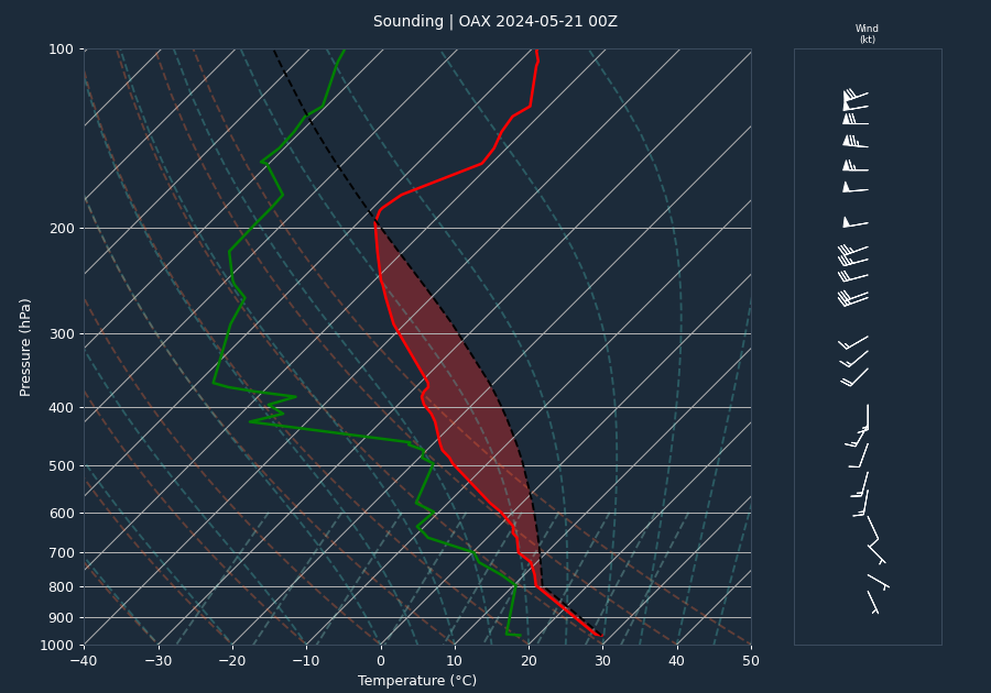
The atmospheric environment leading up to the event was characterized by moderate instability and sufficient shear to support supercell development. The 00:00 UTC sounding from OAX indicated a CAPE of 2645 J/kg, suggesting significant potential for convective development, with a CIN value of 0 J/kg, which facilitated easy convective initiation. The 0-6km bulk shear was measured at 31 knots, placing the environment in a range favorable for supercell formation.

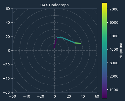
Kinematic data derived from the VAD wind profile at the time of the event showed a 0-1km Storm Relative Helicity (SRH) of 17 m²/s² and a 0-3km SRH of 50 m²/s². These values are relatively low, suggesting that while the thermodynamic environment was highly unstable, the low-level kinematic support for mesocyclone development was modest. It should be noted that the sounding and VAD profiles may under-sample the specific inflow environment of the storms, particularly given the complex evolution of the cold front and the preceding morning's heavy rainfall.

Storm Evolution

Radar analysis from KDMX revealed a highly intense convective system. Throughout the event, the radar consistently recorded maximum inbound and outbound velocities of 69 knots. Because these values remained identical and repeating across multiple scans, it is highly probable that the mesocyclone intensity exceeded the radar's maximum unambiguous velocity threshold (the Nyquist limit), indicating that actual rotational winds were significantly higher than the instrument could natively measure.

The storm exhibited a persistent, intense core, with maximum reflectivity values frequently exceeding 70 dBZ. Notably, echo tops reached as high as 69.9 kft at 20:44 UTC, indicating a powerful, sustained updraft. The descent of high-reflectivity cores, observed alongside spikes in reflectivity height, suggests the presence of large hail and intense precipitation loading within the storm structure during its most violent phases.

Warnings Issued

A total of 10 warnings were issued by the National Weather Service (WFO DMX) during the event, including 9 Tornado Warnings and 1 Severe Thunderstorm Warning. The warning operations were highly effective, particularly regarding the Greenfield tornado. The first tornado warning for the storm system was issued at 19:55:00 UTC, providing a lead time of 32 minutes before the EF4 tornado touched down at 20:27:00 UTC. This lead time significantly exceeded the national average of approximately 13 minutes, providing critical time for public response.

Impacts

The outbreak caused extensive damage across multiple counties. The Greenfield tornado, rated EF4, tracked 43.07 miles with a maximum width of 1600 yards. It caused 5 fatalities and 35 injuries in Adair County, with property damage estimated at $30,000,000. The tornado produced widespread destruction in Greenfield, particularly between SW 3rd Street and SE 3rd Street, where multiple homes were completely destroyed. A Doppler on Wheels (DOW) research team reportedly measured wind speeds of over 300 mph approximately 150 feet above ground level during this event.

Other notable impacts included:

  • Adams County: An EF3 tornado tracked 24.78 miles, resulting in 1 fatality and $1,800,000 in property damage. The tornado caused widespread destruction to farmsteads, industrial wind turbines, and power infrastructure.
  • Adair County: In addition to the EF4, an EF2 tornado tracked 14.63 miles, causing $750,000 in damage to farmsteads and wind energy infrastructure.
  • General Impacts: Across the region, numerous reports of 3-inch tree limbs broken, power pole damage, and hail ranging from penny to half-dollar size were documented. Flash flooding was also reported in Union County.

Conclusion

The May 21, 2024, outbreak was a high-impact event driven by a volatile thermodynamic environment. While the kinematic profile appeared modest, the resulting storms were capable of producing violent, long-track tornadoes. The significant lead time provided by the NWS warning system was a critical factor in the response to this event, though the intensity of the Greenfield tornado resulted in tragic loss of life and extensive structural devastation.

EVENT MAP

Tornado Warning Severe Thunderstorm Warning Tornado Track (DAT/NCEI) LSR

Disclaimer: Tornado tracks use NWS DAT surveyed geometry when available, otherwise NCEI start/end coordinates as straight lines. Actual paths may curve. Width corridors are based on maximum reported width and are approximate.
RADAR LOOP 8 FRAMES
FRAME 01 OF 08 2024-05-21T19:49:48
Base Reflectivity & Velocity (0.5°) - Click image to view all frames
VOLUME SCAN ANALYSIS 8 VOLUMES
Time (UTC) Max dBZ Max Z (kft) 18 Top 50 Top Vel In Vel Out
2024-05-21T19:49:48 72.0 16.4 55.1 39.1 -69.0 69.0
2024-05-21T19:56:43 72.0 13.9 64.0 42.0 -69.0 69.0
2024-05-21T20:03:38 70.0 25.3 64.4 41.2 -69.0 69.0
2024-05-21T20:17:27 68.0 11.4 68.4 40.7 -69.0 69.0
2024-05-21T20:24:22 66.5 19.7 66.2 40.3 -69.0 69.0
2024-05-21T20:31:03 73.0 15.0 64.7 44.0 -69.0 69.0
2024-05-21T20:44:38 69.5 20.6 69.9 43.4 -69.0 69.0
2024-05-21T20:51:33 70.0 18.4 67.3 43.9 -69.0 69.0
ACTIVE WARNINGS 10 ISSUED
Tornado Warning
Issued: 2024-05-21T19:55:00Z
Expires: 2024-05-21T20:45:00Z
Cass [IA], Adair [IA], Adams [IA], Union [IA]
Tornado Warning
Issued: 2024-05-21T20:07:00Z
Expires: 2024-05-21T21:00:00Z
Adams [IA], Taylor [IA], Madison [IA], Adair [IA], Union [IA]
Tornado Warning
Issued: 2024-05-21T20:26:00Z
Expires: 2024-05-21T21:15:00Z
Adair [IA], Union [IA], Adams [IA], Madison [IA]
Tornado Warning
Issued: 2024-05-21T20:35:00Z
Expires: 2024-05-21T21:15:00Z
Dallas [IA], Guthrie [IA], Madison [IA], Adair [IA]
Tornado Warning
Issued: 2024-05-21T20:40:00Z
Expires: 2024-05-21T21:30:00Z
Dallas [IA], Madison [IA], Union [IA], Adams [IA], Adair [IA], Ringgold [IA]
Tornado Warning
Issued: 2024-05-21T20:33:00Z
Expires: 2024-05-21T21:15:00Z
Ringgold [IA], Union [IA], Taylor [IA]
Tornado Warning
Issued: 2024-05-21T20:55:00Z
Expires: 2024-05-21T21:45:00Z
Union [IA], Clarke [IA], Madison [IA], Ringgold [IA], Warren [IA]
Tornado Warning
Issued: 2024-05-21T20:58:00Z
Expires: 2024-05-21T21:45:00Z
Union [IA], Clarke [IA], Decatur [IA], Lucas [IA], Ringgold [IA], Warren [IA]
Severe Thunderstorm Warning
Issued: 2024-05-21T19:28:00Z
Expires: 2024-05-21T20:30:00Z
Adams [IA], Audubon [IA], Cass [IA]
Tornado Warning
Issued: 2024-05-21T19:52:00Z
Expires: 2024-05-21T20:10:00Z
Cass [IA], Adams [IA]
LOCAL STORM REPORTS 32 REPORTS
20:30 UTC (3:30 PM CDT) TSTM WND DMG 6 ESE Bridgewater

Corrects previous tstm wnd dmg report from 3 N Williamson. Damage reported Vehicles flipped, windmills on ground. 1 windmill on fire.

21:18 UTC (4:18 PM CDT) TSTM WND DMG 2 W Murray

Report from mPING. 3-inch tree limbs broken. Power poles broken.

09:21 UTC (4:21 AM CDT) TSTM WND DMG 10 S Dexter

Delayed report of widespread tree damage. Time estimated from radar.

09:37 UTC (4:37 AM CDT) TSTM WND DMG Saint Charles

Large tree down on a car in St. Charles. Time estimated from radar.

09:35 UTC (4:35 AM CDT) TSTM WND DMG 1 ESE Winterset

Trees down on the east side of Winterset. Delayed report on social media. Time estimated from radar.

21:29 UTC (4:29 PM CDT) TSTM WND DMG 1 E Saint Marys

Report from mPING. 3-inch tree limbs broken. Power poles broken.

09:50 UTC (4:50 AM CDT) TSTM WND DMG 3 S Saint Marys

Report from mPING: 3-inch tree limbs broken; Power poles broken.

22:10 UTC (5:10 PM CDT) FLASH FLOOD Lorimor

Reported by Trained Spotter.

08:45 UTC (3:45 AM CDT) TSTM WND GST 61 8 SW Cumberland

PWS KIAGRISW2.

08:39 UTC (3:39 AM CDT) TSTM WND GST 62 Audubon
09:40 UTC (4:40 AM CDT) TSTM WND GST 65 2 N Patterson

Reported by Trained Spotter.

09:49 UTC (4:49 AM CDT) TSTM WND GST 69 Saint Charles

Personal weather station recorded a wind gust of 69.5mph.

09:16 UTC (4:16 AM CDT) TSTM WND GST 75 Greenfield

70 to 75 mph gusts along with dime-sized hail.

20:46 UTC (3:46 PM CDT) HAIL 0.5 1 N Creston
21:18 UTC (4:18 PM CDT) HAIL 0.75 1 S Murray

Report from mPING: penny size hail.

21:43 UTC (4:43 PM CDT) HAIL 0.75 3 S Saint Marys

Report from mPING Penny Size Hail.

20:10 UTC (3:10 PM CDT) HAIL 1 4 S Cumberland
21:31 UTC (4:31 PM CDT) HAIL 1 2 W Murray

Report from mPING: Quarter size hail.

21:07 UTC (4:07 PM CDT) HAIL 1 Winterset
20:42 UTC (3:42 PM CDT) HAIL 1.25 Creston

Estimated half dollar sized hail in Creston. Time estimated with radar.

20:35 UTC (3:35 PM CDT) RAIN 3.08 1 SSE Audubon

AWOS station KADU Audubon Airport.

20:45 UTC (3:45 PM CDT) TORNADO Greenfield

Damage in Greenfield.

20:40 UTC (3:40 PM CDT) TORNADO 3 E Fontanelle

Reported by Trained Spotter.

20:17 UTC (3:17 PM CDT) TORNADO 2 WNW Corning

Confirmed tornado on ground by storm chaser.

20:17 UTC (3:17 PM CDT) TORNADO 3 ESE Corning

Confirmed tornado on the ground by storm chaser (former media).

20:30 UTC (3:30 PM CDT) TORNADO 2 WSW Cromwell

Confirmed tornado on the ground just SW of Cromwell.

20:13 UTC (3:13 PM CDT) TORNADO 2 NNE Corning

Reports of structure damage near Corning.

20:05 UTC (3:05 PM CDT) TORNADO 5 W Corning

Second one.

20:33 UTC (3:33 PM CDT) TORNADO 1 ENE Carbon

Social media report of tornado damage, windmill knocked down and on fire.

20:18 UTC (3:18 PM CDT) TORNADO .5 SW Corning

Tonado near highway 34 at the corner of 240 St and Kentucky. Damage reported.

20:25 UTC (3:25 PM CDT) TORNADO 1 NW Prescott
20:11 UTC (3:11 PM CDT) TORNADO Corning
STORM SURVEY DATA (NCEI) 18 RECORDS
21-MAY-24 14:51:00 Tornado EF0 MADISON County
3.42 mi path 75 yd wide $20,000 property damage

The tornado moved into Madison County from Union County. It impacted two farmsteads, removing a partial roof on an outbuilding along 330th Street and then producing tree damage at another farm along 315th Street with the tornado dissipating shortly afterwards.

21-MAY-24 14:09:00 Tornado EF0 AUDUBON County
7.24 mi path 100 yd wide $10,000 property damage

The tornado developed southeast of Brayton and moved northeast in rural southern Audubon County. The bulk of the damage done was to trees. There was also a TDS associated with this tornado on the radar. The tornado dissipated a few miles east of Exira.

21-MAY-24 14:35:00 Tornado EF0 UNION County
0.35 mi path 75 yd wide $1,000 property damage

This tornado moved into Union County from Adams County just to the northwest of Cromwell. The tornado impacted a few trees on the northwest edge of Cromwell and then dissipated shortly thereafter.

21-MAY-24 14:50:00 Tornado EFU UNION County
0.55 mi path 50 yd wide

This tornado formed in far northern Union County and quickly moved into Madison County. No damage indicators were impacted by this tornado in Union County, hence the EFU rating for this portion of the tornado.

21-MAY-24 15:25:00 Tornado EF0 WARREN County
1.04 mi path 40 yd wide $30,000 property damage

This brief tornado passed through Martensdale producing ample tree damage with minor shingle damage. The tornado also produced a brief TDS on the radar as well. This tornado dissipated after exiting the northeast side of town.

21-MAY-24 14:03:00 Tornado EF3 ADAMS County
15.98 mi path 1300 yd wide $1,000,000 property damage

The tornado entered into Adams County from Montgomery County. This tornado remained in rural areas of western and northern Adams County until lifting north of the town of Carl near the Adair County line. The tornado impacted a house on the north side of 200th street shortly after entering the county removing much of the roof with general collapse of the structure. A large hog confinement facility near the intersection of 190th and Aspen was severally damage with most buildings destroyed. EF3 damage occurred to a house along 175th Street near Cherry Avenue with all wall removed except a couple of the interior walls. The outbuildings at this location were all destroyed as well. Another house along 150th Street near Dogwood Avenue had all but a few interior walls removed with EF3 damage as well. All outbuildings were destroyed at this site as well. The tornado turned slightly to the right at this point with only limited interaction with building sites but plenty of tree damage for the remainder of it path.

21-MAY-24 14:10:00 Hail CASS County

Trained spotter reported quarter sized hail.

21-MAY-24 15:18:00 Hail CLARKE County

Public mping report of penny sized hail.

21-MAY-24 15:07:00 Hail MADISON County

Local media reported quarter sized hail.

21-MAY-24 15:31:00 Hail CLARKE County

Public mping report of quarter sized hail.

21-MAY-24 15:43:00 Hail WARREN County

Public mping report of penny sized hail.

21-MAY-24 14:42:00 Hail UNION County

Public reported roughly half dollar sized hail in Creston. Time estimated from radar.

21-MAY-24 14:27:00 Tornado EF4 ADAIR County
4 deaths 35 injuries 15.74 mi path 1100 yd wide $30,000,000 property damage

This large and violent tornado entered into south central Adair County from Adams County. The tornado remained a multi-vortex circulation as it moved into the county producing high end damage for much of its remaining path. The tornado encountered several houses in the vicinity of Fontanelle Road and 320th Street. Many of the structures received at least EF2 damage with one house north of the intersection receiving up to EF4 damage with a sufficiently anchored structure destroyed and slumped into a debris field nearby. Additional EF4 damage was noted at a farmstead on Jordan Avenue south of 280th Street with the house destroyed and trees chewed down to only the largest trucks and portions of the bark removed. The path then passed through another wind mill area with additional turbines collapsing west of Kent Avenue. The tornado then passed over Nodaway Park Ponds and entered the southwest side of Greenfield along SW 3rd Street. Several structures over the next several blocks had up to EF4 damage from SW 3rd Street over the SE 3rd Street and South of Linn Street and north of Oak and Noble Streets. Most of these saw complete destruction of the house with much of the debris scattered in the area but not completely swept away. The tornado weakened slightly for the later half of the destructive path through Greenfield. EF3 damage was widespread from SE Kent Street and SE 4th Street to the Intersection of E Iowa Street and NE 8th Street. The tornado exited the east side of Greenfield near the Adair County Fairgrounds. The tornado continued east northeast and gradually weakened impacting a few more houses before dissipating just south of the intersection of 220th Street and Quebec Avenue. This tornado produced at least 35 injuries in addition to 4 deaths within Greenfield. All of the deaths occurred in homes. Of note, according to media reports, a Doppler on Wheels (DOW) intercept research team measured a wind speed of just over 300 mph approximately 150 feet above ground level with this tornado.

21-MAY-24 15:29:00 Thunderstorm Wind WARREN County

Public mping report of 3 inch tree limbs broken, power pole damage.

21-MAY-24 15:18:00 Thunderstorm Wind CLARKE County

Public mping report of 3 inch tree limbs broken, power pole damage.

21-MAY-24 14:39:00 Tornado EF2 ADAIR County
14.63 mi path 200 yd wide $750,000 property damage

Emergency management recorded a path of damage from just east of Greenfield to just shy of the Adair/Madison County line north of 140th Street. The initial portion of this tornado was observed via the Doppler on Wheels (DOW) and was extended farther southwest accordingly. This tornado impacted farmsteads with damage to outbuildings and tree groves. Toward the end of the path, a large industrial wind mill was blown over southeast of the intersection of 150th street and Walnut Avenue. EF2 damage was then done with complete destruction of an outbuilding along York Avenue along with shredding of trees. The tornado then quickly weakened and dissipated as it approached the county line.

21-MAY-24 15:28:00 Tornado EF0 WARREN County
2 mi path 75 yd wide $10,000 property damage

Numerous reports via social media of tree damage associated with this tornado. It also produced a TDS on radar as it moved to the northeast.

21-MAY-24 14:00:00 Tornado EF3 ADAMS County
1 deaths 24.78 mi path 1600 yd wide $1,800,000 property damage

The tornado entered into Adams County after clipping the northwest corner of Taylor County. Damage was immediate on the county border with damage to trees and and to farm buildings and power poles within the first few miles in the county. The tornado continued to gain in strength and size as it travelled northeast through southwest Adams county remaining in rural areas south and east of Nodaway. The tornado eventually crossed Federal Highway 34 just north of Brooks with plenty of videos showing a large funnel with debris swirling below it. As the tornado crossed State Highway 148, it gained in strength with EF2 damage becoming more common. Upon reaching the intersection of 150th Street and Notchwood Avenue, EF3 damage occurred with much of an unanchored house losing walls and sliding off the foundation. All outbuildings at this site were also destroyed. As the tornado continued into the north central portion of the county, it encountered several industrial wind mills. Several of the towers collapsed along with the large blades being tossed hundreds of feet through the air. The tornado was multi-vortex at this point with a width of 1300 yards. The tornado exited the county into Adair County between Quince Avenue and Redwood Avenue. The was one death in the county from this tornado when a female driver was ejected from a vehicle which got caught within the circulation.

Source: NOAA NCEI Storm Events Database - post-survey verified records