Overview
On May 22, 2011, a catastrophic severe weather outbreak impacted southwestern Missouri and portions of northeastern Oklahoma and southeastern Kansas. The event was characterized by multiple supercell thunderstorms, including a long-track, violent EF-5 tornado that devastated the city of Joplin, Missouri. The episode resulted in 158 direct fatalities and 1,154 direct injuries, with total damage across the region reaching into the billions of dollars.
Environmental Context
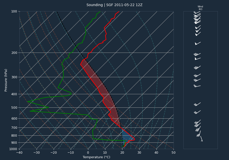
The regional environment was primed for severe convective development. A pre-event sounding from Springfield, Missouri, indicated moderate instability with a CAPE of 1661 J/kg and a CIN of -252 J/kg. While these values suggest a capped environment, the 0-6km bulk shear of 39 knots provided sufficient organization for supercell development. It is important to note that the sounding likely under-sampled the warm-sector instability present at the time of the event, as the storm environment was significantly more volatile than the morning profile suggested.
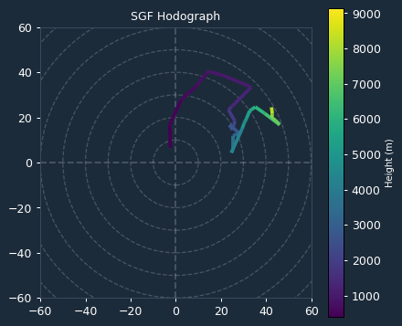
Kinematic data derived from the VAD wind profile at the time of the event revealed a highly supportive environment for tornadogenesis. The 0-1km Storm Relative Helicity (SRH) was 437 m²/s², and the 0-3km SRH was also 437 m²/s². These significant SRH values indicate strong low-level wind shear, which played a critical role in the development and maintenance of the intense mesocyclone that produced the Joplin tornado.
Storm Evolution
The storm system exhibited classic supercell characteristics throughout its lifecycle. Radar analysis from KSGF showed persistent, intense rotation, with inbound and outbound velocities consistently reaching 65.1 knots. Because these values remained identical across multiple scans, it is evident that the mesocyclone exceeded the radar's maximum unambiguous velocity threshold, indicating that actual rotational winds were significantly higher than the instrument could measure.
The storm displayed significant intensification trends, with max reflectivity values frequently exceeding 70 dBZ. A notable core descent was observed, where the height of the maximum reflectivity dropped from 23.3 kft at 22:58 UTC to 17.1 kft by 23:03 UTC, coinciding with the period of maximum tornadic intensity. Echo tops remained high, often exceeding 50 kft, confirming the presence of a robust, sustained updraft.
Warnings and Lead Time
The National Weather Service issued a series of warnings to communicate the extreme risk. The first tornado warning for the Joplin area was issued at 22:17 UTC. Given that the EF-5 tornado touched down at 22:40 UTC, the lead time for the event was 23 minutes. This lead time significantly exceeded the national average of approximately 13 minutes, providing a critical window for public response despite the extreme intensity of the storm.
Impacts
The Joplin tornado, rated EF-5, tracked for 8.8 miles through Jasper County and continued into Newton County, with a total path length of 21.6 miles and a maximum width of one mile. The storm caused 158 direct deaths and 1,154 direct injuries. Property damage was immense, with 7,000 homes destroyed or severely damaged, and major infrastructure including St. John's Hospital, Joplin High School, and several large retail centers leveled. Debris accumulation was estimated at 2 million cubic yards.
Beyond the primary EF-5 event, the broader episode included an EF-3 tornado that moved from Delaware County, Oklahoma, into McDonald County, Missouri, causing two injuries and destroying multiple residences. Additional tornadoes, including EF-2 events in Lawrence and Newton Counties, contributed to widespread power pole and tree damage. Flash flooding also occurred in the aftermath, particularly in Seneca and Neosho, Missouri, where numerous homes and businesses were inundated.
Conclusion
The May 22, 2011, event remains one of the most significant weather disasters in modern history. The combination of high SRH values and a strongly sheared environment supported the development of a violent, cyclic supercell. While the 23-minute lead time provided by the NWS was well above average, the sheer scale and intensity of the EF-5 tornado resulted in unprecedented loss of life and structural destruction in Joplin.