SWX
Severe Weather Event Reporter
EVENT REPORT KANKAKEE, KANKAKEE COUNTY, ILLINOIS, 60901, UNITED STATES

KANKAKEE AROMA PARK TORNADO

March 10, 2026

The event narrative is AI-generated from structured meteorological data and may contain errors. Verify critical facts against the NCEI, NWS, and LSR data sections below.

IMPACT SUMMARY
Warning Lead Time
2 min
before touchdown
Path Length
35.6
mi (DAT surveyed)
Max Reflectivity
74.0
dBZ
Echo Tops
69.4
kft (18 dBZ)
Warnings
5
NWS issued
Storm Reports
32
LSRs filed
PRE-EVENT SOUNDING & VAD WINDS ILX 2026-03-11

Skew-T Log-P

Pre-event sounding

Ambient Hodograph (Event-Time)

Ambient Hodograph
CAPE
2564
J/kg
CIN
-7
J/kg
0-6km Shear
48
knots
Sfc Temp
26.2
°C
Sfc Dewpoint
18.2
°C
Sfc Pressure
984.0
hPa
0-1km SRH
214
m²/s²
0-3km SRH
342
m²/s²

Skew-T: nearest pre-event balloon launch from ILX - Source: IEM RAOB Archive / University of Wyoming. Hodograph derived from VAD winds extracted from event-time radar velocity data.

EVENT NARRATIVE

Event Overview

On March 10, 2026, a significant weather event impacted Kankakee County, Illinois, and portions of Newton County, Indiana. The event, classified as an EF-3 tornado with estimated peak winds near 150 mph, resulted in two fatalities and extensive structural damage. The path of the tornado extended 36.6 miles, beginning west of the Kankakee Airport and dissipating in far northwest Jasper County.

Storm Evolution

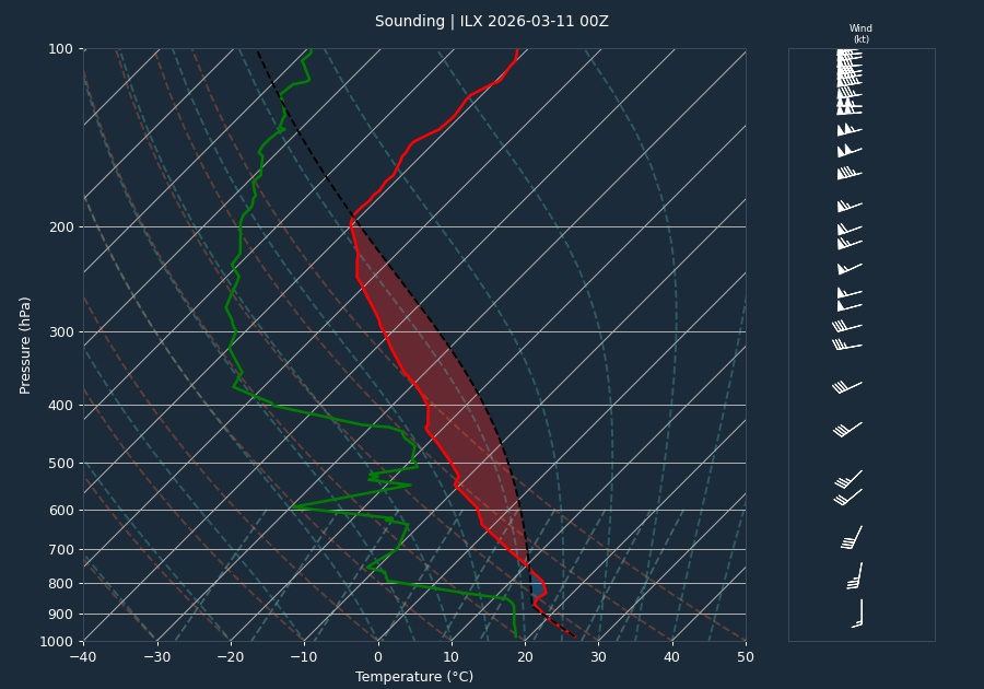
Radar data from the KLOT site between 23:01 UTC on March 10 and 01:50 UTC on March 11 indicated a persistent, intense storm system. Reflectivity values remained consistently high, frequently exceeding 70 dBZ, with a peak of 74.0 dBZ recorded at 01:38 UTC. Echo tops for the 18 dBZ threshold reached as high as 69.4 kft at 00:19 UTC. Throughout the duration of the radar scans provided, inbound and outbound velocities remained locked at -64.1 knots and 64.1 knots, respectively.

Warnings Issued

The National Weather Service office in Chicago (LOT) issued a series of warnings as the storm progressed:

  • Severe Thunderstorm Warning (LOT.SV.W.0012): Issued at 23:02 UTC, covering Will and Kankakee Counties.
  • Severe Thunderstorm Warning (LOT.SV.W.0013): Issued at 23:09 UTC, covering Kankakee County.
  • Tornado Warning (LOT.TO.W.0003): Issued at 23:16 UTC, covering Kankakee County.
  • Severe Thunderstorm Warning (LOT.SV.W.0014): Issued at 23:45 UTC, covering Kankakee, Will, Lake, and Newton Counties.
  • Tornado Warning (LOT.TO.W.0004): Issued at 23:55 UTC, covering Kankakee, Lake, and Newton Counties.

Impacts

The event caused widespread damage across Kankakee and Newton Counties. Notable impacts include:

  • Fatalities: Two fatalities were reported in Newton County, Indiana, where three manufactured homes were completely destroyed on 600 West Road north of 800 North Road.
  • Structural Damage: Significant damage was reported near the Kankakee Airport, including roof damage near West Industrial Park Drive and Stuart Drive. Additional damage to structures and a solar farm was documented near 2000 South Road and 3000 East Road in Aroma Park. In Lake Village, Indiana, commercial signs and structures sustained damage near US-41 and 300 West Road.
  • Hail: The event produced extreme hail, with multiple reports of baseball-sized (2.75 inch) to softball-sized (4 inch) hail. A notable hailstone measuring 6.14 inches in diameter was recovered on Osborn Ave in Kankakee, which is a candidate for the Illinois state record.
  • Non-Convective Wind: A non-convective wind gust of 55 mph was recorded at the Kankakee Airport (KIKK) on March 13 at 16:35 UTC.

Conclusion

The March 10, 2026, event was a high-impact weather occurrence characterized by an EF-3 tornado and record-setting hail. While the NCEI database currently lists zero formal records for this event, Local Storm Reports (LSRs) provide comprehensive documentation of the destruction and the tragic loss of life in Newton County. The storm exhibited sustained high reflectivity and velocity signatures throughout its lifecycle, consistent with the severe damage reported on the ground.

EVENT MAP

Tornado Warning Severe Thunderstorm Warning Tornado Track (DAT/NCEI) LSR

Disclaimer: Tornado tracks use NWS DAT surveyed geometry when available, otherwise NCEI start/end coordinates as straight lines. Actual paths may curve. Width corridors are based on maximum reported width and are approximate.
RADAR LOOP 16 FRAMES
FRAME 01 OF 16 2026-03-11T00:01:16
Base Reflectivity & Velocity (0.5°) - Click image to view all frames
VOLUME SCAN ANALYSIS 16 VOLUMES
Time (UTC) Max dBZ Max Z (kft) 18 Top 50 Top Vel In Vel Out
2026-03-11T00:01:16 73.0 4.8 58.7 43.9 -64.1 64.1
2026-03-11T00:07:16 73.0 3.5 68.4 42.0 -64.1 64.1
2026-03-11T00:13:15 73.5 10.9 67.1 40.4 -64.1 64.1
2026-03-11T00:19:27 70.0 4.1 69.4 42.2 -64.1 64.1
2026-03-11T00:31:39 70.0 3.5 66.6 35.9 -64.1 64.1
2026-03-11T00:37:39 69.5 10.9 65.6 39.7 -64.1 64.1
2026-03-11T00:43:39 72.0 7.5 68.3 39.8 -64.1 64.1
2026-03-11T00:49:51 71.0 8.7 60.5 40.4 -64.1 64.1
2026-03-11T01:02:14 70.5 8.0 65.7 41.7 -64.1 64.1
2026-03-11T01:08:25 71.0 8.8 64.4 38.4 -64.1 64.1
2026-03-11T01:14:37 71.5 7.2 68.1 36.5 -64.1 64.1
2026-03-11T01:20:37 73.0 9.4 68.9 42.6 -64.1 64.1
2026-03-11T01:32:47 71.0 10.6 67.5 41.0 -64.1 64.1
2026-03-11T01:38:48 74.0 10.3 57.1 39.9 -64.1 64.1
2026-03-11T01:44:48 73.5 10.0 68.7 39.1 -64.1 64.1
2026-03-11T01:50:48 71.5 11.8 57.3 38.3 -64.1 64.1
ACTIVE WARNINGS 5 ISSUED
Severe Thunderstorm Warning
Issued: 2026-03-10T23:02:00Z
Expires: 2026-03-11T00:00:00Z
Will [IL], Kankakee [IL]
Severe Thunderstorm Warning
Issued: 2026-03-10T23:09:00Z
Expires: 2026-03-11T00:15:00Z
Kankakee [IL]
Tornado Warning
Issued: 2026-03-10T23:16:00Z
Expires: 2026-03-11T00:00:00Z
Kankakee [IL]
Severe Thunderstorm Warning
Issued: 2026-03-10T23:45:00Z
Expires: 2026-03-11T01:00:00Z
Kankakee [IL], Will [IL], Lake [IN], Newton [IN]
Tornado Warning
Issued: 2026-03-10T23:55:00Z
Expires: 2026-03-11T00:30:00Z
Kankakee [IL], Lake [IN], Newton [IN]
LOCAL STORM REPORTS 32 REPORTS
23:30 UTC (6:30 PM CDT) TSTM WND DMG 1 WNW Aroma Park

Multiple photos shared to social media show damage to structures and trees near Waldron Road and Marquette Lane near Aroma Park. Possible tornado. Time estimated by radar.

23:39 UTC (6:39 PM CDT) TSTM WND DMG 3 S Sun River Terrace

Power lines downed on East 2250 South Road south of Sun River Terrace. Relayed via off duty NWS employee. Possible tornado, time estimated by radar.

23:23 UTC (6:23 PM CDT) TSTM WND DMG 1 NW Kankakee Airport

Roof damaged near West Industrial Park Drive and Stuart Drive in Kankakee. Possible tornado. Time estimated by radar.

23:31 UTC (6:31 PM CDT) TSTM WND DMG 1 NNW Aroma Park

Videos and photos shared to social media show damage to structures and solar farm near 2000 South Road and 3000 East Road north of Aroma Park. Possible tornado.

00:12 UTC (7:12 PM CDT) TSTM WND DMG 1 S Lake Village

Multiple photos and videos shared to social media show damage to structures and commercial signs near US-41 and 300 West Road on the south side of Lake Village. Time estimated by radar. Possible tornado.

23:41 UTC (6:41 PM CDT) HAIL 1 1 WSW Sun River Terrace

Reported at Route 17 and Sandbar Road.

03:25 UTC (10:25 PM CDT) HAIL 1 Grant Park
23:44 UTC (6:44 PM CDT) HAIL 1.75 Momence

Multiple reports of hail in Momence. The largest hailstones were estimated to be the size of golf balls.

23:20 UTC (6:20 PM CDT) HAIL 2 Bradley

Hail broke windows in Bradley.

23:00 UTC (6:00 PM CDT) HAIL 2 1 SE Bonfield

Relayed via amateur radio.

23:27 UTC (6:27 PM CDT) HAIL 2.75 2 S Kankakee

Baseball size hail reported on the south side of Kankakee. Relayed via social media. Time estimated by radar.

23:10 UTC (6:10 PM CDT) HAIL 2.75 3 N Irwin

Photo shared to social media shows 4 inch diameter hail near Irwin. Time estimated by radar.

23:20 UTC (6:20 PM CDT) HAIL 2.75 3 W Kankakee Airport

Report from mPING.

23:32 UTC (6:32 PM CDT) HAIL 3 Kankakee

3 inch diameter hail reported in Kankakee. Relayed via amateur radio.

23:10 UTC (6:10 PM CDT) HAIL 3 Bourbonnais

Multiple public reports of hail in Bourbonnais. The largest hailstones were measured to be 3 inches in diameter.

23:25 UTC (6:25 PM CDT) HAIL 4 2 WSW Kankakee

delayed report.

23:31 UTC (6:31 PM CDT) HAIL 4 1 SE Kankakee

Photo shared to social media shows softball size hail near Beckman Park in Kankakee. Time estimated by radar.

23:35 UTC (6:35 PM CDT) HAIL 4.1 1 NW Aroma Park
23:11 UTC (6:11 PM CDT) HAIL 4.5 1 W Bourbonnais

Correction to date. Public report of hail up to Grapefruit size near Plum Creek Drive and Braemer Way in Bourbonnais. Time estimated by radar.

23:27 UTC (6:27 PM CDT) HAIL 4.5 1 NW Kankakee Airport

Photo shared to social media shows approximately 4.5 inch diameter hail on the south side of Kankakee. Time estimated by radar.

23:11 UTC (6:11 PM CDT) HAIL 4.5 1 W Bourbonnais

Public report of hail up to Grapefruit size near Plum Creek Drive and Braemer Way in Bourbonnais. Time estimated by radar.

23:11 UTC (6:11 PM CDT) HAIL 4.5 1 NNE Kankakee
23:23 UTC (6:23 PM CDT) HAIL 5.2 3 SW Kankakee

Photo shared by storm chaser shows 5.2 inch diameter hail just southwest of Kankakee.

23:30 UTC (6:30 PM CDT) HAIL 6 1 SE Kankakee

Photo shows hailstone approximately 6 inches in diameter in southeastern Kankakee. Time estimated by radar.

23:28 UTC (6:28 PM CDT) HAIL 6.1 1 SSE Kankakee

A hailstone measuring 156 mm or 6.14 inches in diameter, 16 inches in circumference, and 16.25 oz in weight was found on Osborn Ave in Kankakee, Illinois. The hailstone is a candidate for Illinois state record hailstone. Time estimated by radar.

16:35 UTC (11:35 AM CDT) NON-TSTM WND GST 55 Kankakee Airport

AWOS station KIKK Kankakee Airport.

23:18 UTC (6:18 PM CDT) TORNADO 3 W Kankakee Airport

*** 2 FATAL *** A tornado begin just west of the Kankakee Airport and tracked 36.6 miles across Kankakee and Newton Counties before dissipating in far northwest Jasper County. This tornado has been rated an EF-3 with estimated peak winds near 150 mph.

23:59 UTC (6:59 PM CDT) TORNADO 4 NE Hopkins Park

Indiana state police reports tornado on the ground visible from near IN-10 and 600 West Road.

23:24 UTC (6:24 PM CDT) TORNADO 1 NW Kankakee Airport

Kankakee County EMA reports tornado touch down near I-57 and Justice Way. Time estimated by radar.

23:54 UTC (6:54 PM CDT) TORNADO 2 N Hopkins Park

Multiple reports of a tornado crossing Main Street on the north side of Hopkins Park. Relayed via amateur radio. Time estimated by radar.

23:27 UTC (6:27 PM CDT) TORNADO 1 N Kankakee Airport

Video shows tornado on the ground near the Kankakee Airport.

00:08 UTC (7:08 PM CDT) TORNADO 3 WSW Lake Village

*** 2 FATAL *** Three manufactured homes completed destroyed on 600 West Road north of 800 North Road. Two persons killed in one residence. Relayed by broadcast media.