Overview
On March 15, 2025, a significant severe weather outbreak impacted portions of Mississippi and Louisiana, characterized by a series of intense, long-tracked tornadoes. The event was headlined by a violent EF-4 tornado that tracked over 67 miles from Tangipahoa Parish, Louisiana, through Walthall, Marion, and Jefferson Davis counties in Mississippi. In total, the event produced 12 confirmed tornadoes, resulting in 7 direct fatalities and 8 direct injuries.
Environmental Context
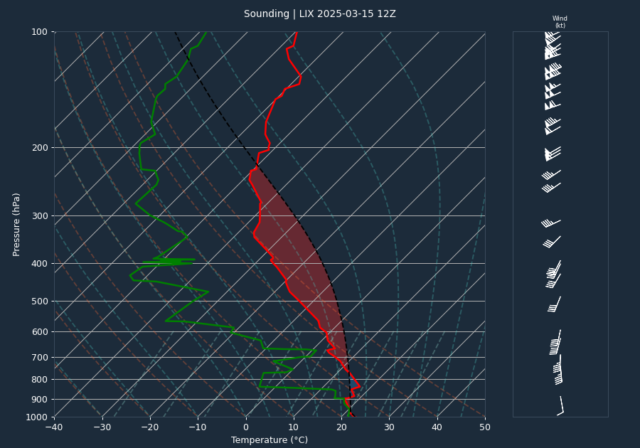
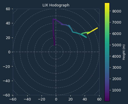
The atmospheric environment was highly favorable for the development of long-lived, violent tornadoes. A pre-event sounding from LIX indicated moderate instability with a CAPE of 2468 J/kg and negligible convective inhibition (CIN of 0 J/kg), allowing for easy convective initiation. The kinematic environment was particularly supportive of supercell development and mesocyclone rotation, with 0-6km bulk shear measured at 42 knots. Furthermore, the VAD wind profile at the time of the event showed significant low-level shear, with 0-1km Storm Relative Helicity (SRH) at 227 m2/s2 and 0-3km SRH at 304 m2/s2. These values provided the necessary rotation and organization to sustain the violent tornadic activity observed throughout the day.
Storm Evolution
Radar analysis from the KHDC site tracked the evolution of the primary storm system. Throughout the event, the storm maintained a consistent velocity couplet with maximum inbound and outbound velocities of 62.2 knots. Radar scans showed significant vertical development, with echo tops reaching as high as 68.2 kft at 17:23:01 UTC. The system exhibited signs of intensification, with reflectivity cores frequently descending toward the surface, including a scan at 18:33:09 UTC showing a maximum reflectivity of 75.0 dBZ at a height of 6.6 kft, indicating a robust and concentrated precipitation core associated with the tornadic vortex.
Warnings Issued
A total of 9 warnings were issued by WFOs JAN and LIX, including 7 Tornado Warnings and 2 Severe Thunderstorm Warnings. The warning system proved highly effective for this event. Specifically, the first tornado warning for the system that produced the EF-4 tornado was issued at 17:39:00 UTC, providing 56 minutes of lead time before the tornado reached its peak intensity and touched down in the affected areas. This lead time significantly exceeded the national average of approximately 13 minutes, allowing residents crucial time to seek shelter.
Impacts
The event resulted in widespread destruction across multiple counties. The primary EF-4 tornado, which reached maximum wind speeds of 170 mph and a width of 1400 yards, caused 3 fatalities in Walthall County and 2 in Jefferson Davis County. A second EF-3 tornado, which tracked near the path of the EF-4, resulted in 1 fatality in Walthall County. An additional EF-2 tornado in Marion and Jefferson Davis counties resulted in 1 fatality and 1 injury. Across all records, the total path length for the dominant tornado system was 61.2 miles. Damage reports included the total destruction of well-anchored homes, the demolition of numerous manufactured homes, and extensive tree damage. In Forrest County, non-tornadic thunderstorm winds reached a peak gust of 58 mph (50 kt) at the Hattiesburg-Bobby L Chain Municipal Airport.
Conclusion
The March 15, 2025, event was a high-impact severe weather episode driven by a volatile combination of moderate instability and significant low-level shear. The long-tracked nature of the tornadoes, particularly the EF-4 system, caused substantial loss of life and property damage. Despite the severity of the storms, the extensive lead time provided by the NWS warning system was a critical factor in public safety during this violent weather event.