Overview
On August 10, 2020, a powerful and destructive derecho tracked across eastern Iowa and northwest Illinois, producing widespread, extreme straight-line wind damage. While the event was primarily characterized by a massive swath of damaging winds, a brief tornado was confirmed in Linn County, Iowa. The event resulted in one direct fatality and 100 injuries, with total damage estimates reaching approximately 7.5 billion dollars across the affected region.
Environmental Context
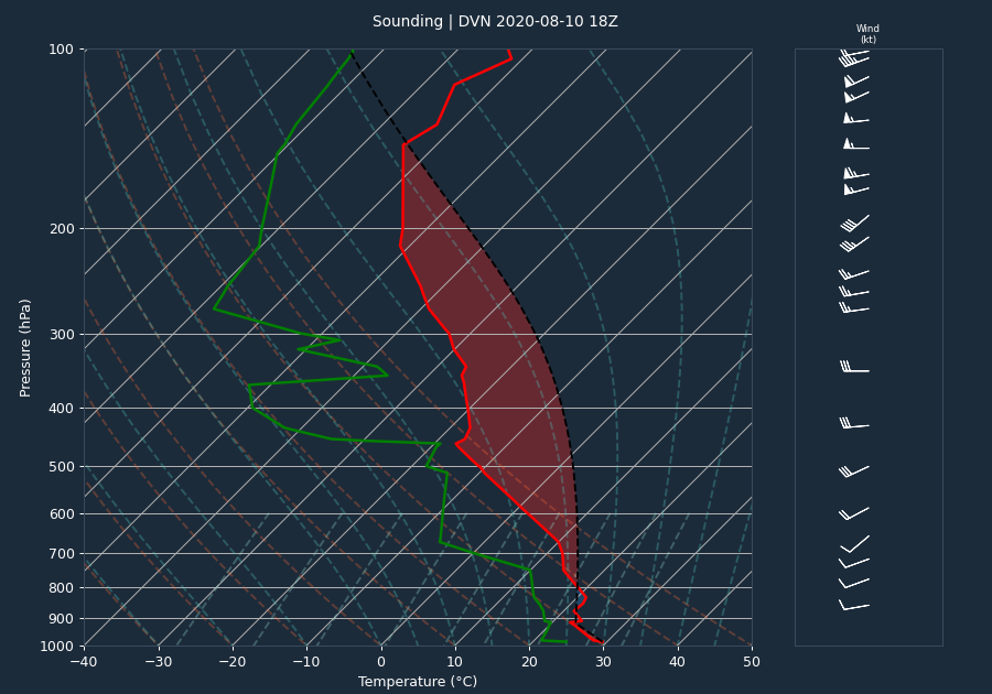
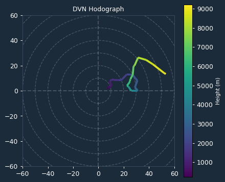
The atmospheric environment was characterized by extreme instability, with the pre-event sounding at Davenport (DVN) indicating a CAPE value of 4702 J/kg and a CIN of 0 J/kg, signaling a highly unstable atmosphere with no inhibition to convective development. While the 0-6km bulk shear was measured at a modest 15 knots, the kinematic environment at the time of the storms was better represented by the VAD wind profile. This profile showed a 0-3km Storm Relative Helicity (SRH) of 159 m2/s2, which is favorable for mesocyclone development. The 0-1km SRH was 28 m2/s2, indicating a lower potential for near-surface rotation, which aligns with the brief and transient nature of the tornado observed.
Storm Evolution
The derecho was characterized by a long-duration, high-intensity wind event. Radar data from KDVN tracked the intensification of the storm system throughout the afternoon. Reflectivity values frequently exceeded 65 dBZ, with peak values reaching 75 dBZ. The system exhibited a persistent rear inflow jet, with maximum inbound and outbound velocities reaching 65.1 knots. The duration of the strong winds was notable, with many locations experiencing gusts over 60 mph for over an hour. The most extreme wind speeds were estimated between 110 and 140 mph, causing catastrophic damage to infrastructure, including the collapse of radio transmission towers in Marion and Clinton, Iowa.
Warnings Issued
The National Weather Service issued six Severe Thunderstorm Warnings (ETNs 159, 161, 162, 163, 164, and 165) to address the rapidly evolving derecho. These warnings covered a broad area of eastern Iowa and northwest Illinois, including Linn, Benton, Johnson, Cedar, Clinton, and Scott counties. The warnings effectively communicated the threat of extreme winds, which were observed to reach 122 knots in Linn County. Lead time was critical given the rapid progression of the rear inflow jet, which produced wind gusts of 80-100 mph across the Quad Cities area.
Impacts
The impacts of the derecho were widespread and severe. In Linn County, a brief EF-U tornado was confirmed just north of the Eastern Iowa Airport, with a path length of 0.92 miles and a width of 40 yards. While no damage was directly attributable to the tornado itself, it occurred within a larger swath of straight-line winds that caused extensive destruction. One fatality occurred in Linn County when a tree fell on a 63-year-old cyclist. Numerous injuries were reported in the Cedar Rapids area, where apartment complexes, businesses, and homes sustained damage consistent with 130-140 mph winds. Across the derecho path, thousands of trees were snapped or uprooted, and long-duration power outages were widespread. In Clinton County, a radio transmission tower collapsed due to estimated 130 mph winds, and in Bureau County, Illinois, a 150-foot communications tower was destroyed. Agricultural impacts were also significant, with considerable damage to crops and grain bins reported throughout the affected counties.
Conclusion
The August 10, 2020, derecho was a once-in-a-decade event for the region, distinguished by both its extreme intensity and the unusual duration of hurricane-force wind gusts. The combination of high instability and favorable kinematic support allowed the system to maintain its strength as it moved through eastern Iowa and northwest Illinois, resulting in historic levels of property damage and significant impacts to the local population.