Overview
On May 12, 2026, a severe weather event impacted Pasco County, Florida, resulting in two confirmed tornadoes near New Port Richey and Hudson. The event occurred during the late afternoon hours, with damage surveys confirming two separate EF0 tornadoes. No fatalities or injuries were reported in association with these events.
Environmental Context
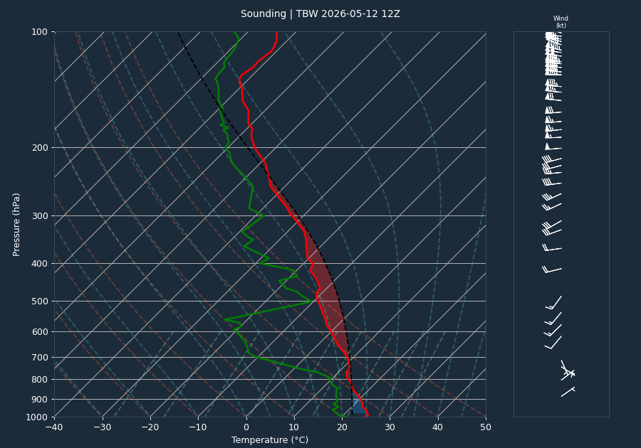
The regional environment was characterized by marginal instability and sufficient shear to support convective development. The 12:00 UTC sounding from the Tampa Bay area indicated a CAPE value of 952 J/kg, which is considered marginal for severe weather. The CIN value of -74 J/kg suggested a degree of capping in the atmosphere. The 0-6km bulk shear was measured at 35 knots, a value supportive of supercell development. It should be noted that the sounding likely under-samples the warm-sector instability present at the time of the event, as the profile is a regional snapshot rather than a direct measurement of the storm's immediate inflow environment.
Kinematic data derived from the VAD wind profile at the time of the event provided further insight into the storm environment. The 0-1km Storm Relative Helicity (SRH) was 31 m²/s², and the 0-3km SRH was 102 m²/s². These values indicate a relatively weak environment for mesocyclone development, consistent with the observed EF0 intensity of the tornadoes.
Storm Evolution
Radar analysis from KTBW shows that the parent storm maintained a consistent convective structure throughout the afternoon. Reflectivity values frequently exceeded 65 dBZ, with a peak of 75.0 dBZ observed at 16:49 UTC. Echo tops remained elevated, generally ranging between 58 and 65 kft, indicating a sustained updraft. Throughout the event, inbound and outbound velocities reached the radar's effective measurement limit (Nyquist), indicating strong rotation within the storm core. A trend of core descent was observed as the storm approached the Hudson area, with the height of maximum reflectivity dropping from 10.4 kft at 17:41 UTC to 6.2 kft by 18:20 UTC, shortly before the reported tornado activity.
Warnings Issued
Two Tornado Warnings were issued by WFO Tampa Bay (TBW) for Pasco County. The first warning (TBW.TO.W.0001) was issued at 17:41 UTC and remained in effect until 18:30 UTC. A second warning (TBW.TO.W.0002) was issued at 18:24 UTC, covering both Hernando and Pasco Counties, and remained in effect until 19:00 UTC.
Warning effectiveness was high, with the second tornado warning providing a lead time of 13 minutes before the tornado was reported at 18:37 UTC. This lead time aligns with the national average for tornado warnings, allowing for adequate public notification prior to the onset of tornadic damage.
Impacts
Damage surveys conducted by the NWS confirmed two EF0 tornadoes in Pasco County:
- Hudson Tornado: This EF0 tornado tracked for 1.1872 miles with a maximum width of 400 yards and peak winds of 85 mph.
- Shady Hills Tornado: This EF0 tornado tracked for 0.6881 miles with a maximum width of 250 yards and peak winds of 85 mph.
Local Storm Reports (LSRs) corroborated the radar and survey findings. At 18:29 UTC, a wind gust of 54 mph was recorded at Hudson Beach Park. At 18:30 UTC, a marine thunderstorm wind of 45 mph was reported 1 NE of Hudson. At 18:37 UTC, Pasco County Dispatch reported roof damage 1 SSW of Hudson, which was subsequently confirmed as tornadic in nature. There were no direct fatalities or injuries reported.
Conclusion
The May 12, 2026, event in Pasco County was a localized severe weather episode that produced two EF0 tornadoes. Despite the marginal instability indicated by regional soundings, the storm was able to produce damaging winds and structural damage to roofs in the Hudson area. Timely warnings issued by WFO Tampa Bay ensured that the public had sufficient lead time, contributing to the lack of casualties during this event.