Overview
On the evening of March 24, 2023, a historic and violent long-track tornado impacted portions of western and central Mississippi. The tornado, which reached a maximum intensity of EF4, carved a path of destruction across Sharkey, Issaquena, Humphreys, and Holmes counties. This event resulted in 22 direct fatalities and 225 direct injuries, causing catastrophic damage to the city of Rolling Fork and surrounding communities.
Environmental Context
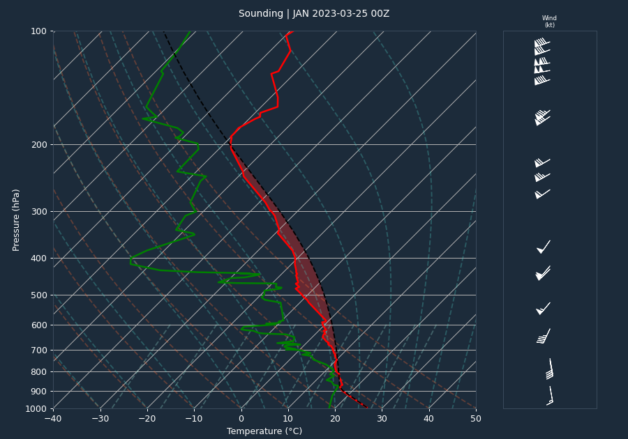
The atmospheric environment on the evening of March 24 was highly favorable for the development of intense, long-lived supercells. The pre-event sounding from Jackson, MS, indicated moderate instability with a CAPE of 1043 J/kg and a CIN of 0 J/kg, suggesting that the atmosphere was primed for convective initiation with little to no capping inhibition. The 0-6km bulk shear was measured at 55 knots, a value strongly supportive of supercell development.
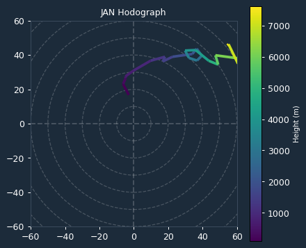
Kinematic data derived from the VAD wind profile at the time of the event provided further evidence of a volatile environment. The 0-1km Storm Relative Helicity (SRH) was 179 m²/s², while the 0-3km SRH reached 348 m²/s². These elevated SRH values were critical in supporting robust mesocyclone development and provided the necessary low-level rotation to sustain a violent, long-track tornado.
Storm Evolution
The tornado began in northern Issaquena County at 18:57 CST and tracked northeastward, entering Sharkey County where it underwent rapid intensification. Radar analysis from KDGX indicates that the storm maintained a high-reflectivity core, with values frequently exceeding 65 dBZ. Between 00:54 and 01:24 UTC, the radar velocity couplet consistently saturated at 65.1 knots, indicating that the rotational winds within the mesocyclone exceeded the instrument's maximum unambiguous velocity threshold. The descent of the high-reflectivity core, observed as the height of maximum reflectivity dropped to 5.6 kft by 01:37 UTC, coincided with the period of peak intensity as the tornado moved through Rolling Fork and toward Silver City.
Warnings and Lead Time
The National Weather Service issued three warnings associated with this event. The first tornado warning (VTEC ID: JAN.TO.W.0028) was issued at 00:53 UTC on March 25. Given that the tornado reached its peak intensity and touched down in the most heavily impacted areas around 01:03 UTC, the lead time for the warning was 10 minutes. While this provided a window for protective action, the lead time was slightly below the national average of 13 minutes, reflecting the rapid intensification and violent nature of this long-track system.
Impacts
The tornado caused widespread destruction along a path totaling 88.7 miles across all affected counties. In Sharkey County, the tornado reached EF4 intensity, devastating Rolling Fork. Significant damage included the destruction of the Sharkey-Issaquena Community Hospital, the leveling of a Masonic lodge, and the total destruction of a mobile home park along US Highway 61 where 30-35 homes were destroyed and six fatalities occurred. Across the entire episode, 22 people lost their lives, and 225 were injured. Property damage was extensive, with the tornado destroying homes, businesses, and critical infrastructure, including a water tower and multiple utility transmission lines. In Humphreys County, the tornado continued to produce EF3 damage, destroying homes in Silver City and causing two additional fatalities.
Conclusion
The Rolling Fork tornado of March 24, 2023, represents a significant and tragic event in Mississippi's meteorological history. The combination of moderate instability and strong wind shear created an environment conducive to a violent, long-track supercell. Despite the issuance of timely warnings, the intensity and rapid evolution of the storm resulted in catastrophic impacts across the Mississippi Delta.