Post-Event Report: June 11, 2026 Streator Tornado
On the evening of June 11, 2026, a significant severe weather outbreak impacted portions of north-central Illinois. The event was characterized by multiple tornadoes, including a high-end EF3 tornado that tracked through the Streator area, resulting in seven injuries. This report synthesizes the environmental conditions, radar evolution, and warning performance associated with the event.
Environmental Context
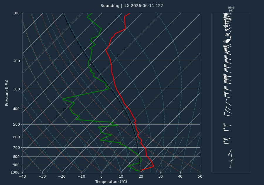
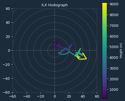
The atmospheric environment on June 11, 2026, was characterized by a high-shear, low-instability regime. The 12:00 UTC sounding from Lincoln, Illinois (ILX), indicated 0 J/kg of CAPE and 0 J/kg of CIN, suggesting that the balloon sounding likely under-sampled the warm-sector instability present during the evening hours. Despite the lack of measured instability, the 0-6km bulk shear was recorded at 35 knots, a value sufficient to support organized convective structures such as supercells.
Kinematic data derived from the VAD wind profile at the time of the event showed 0-1km Storm Relative Helicity (SRH) of 73 m²/s² and 0-3km SRH of 32 m²/s². These values indicate a relatively modest environment for low-level rotation; however, the presence of these shear profiles in conjunction with the observed supercellular development contributed to the tornadic activity.
Storm Evolution
Radar data from the KLOT WSR-88D captured the intensification of the storm system. At 22:30 UTC, the storm exhibited a maximum reflectivity of 71.0 dBZ with echo tops reaching 67.4 kft. As the storm progressed, a notable core descent was observed; the height of the maximum reflectivity dropped from 25.2 kft at 22:30 UTC to 7.6 kft by 22:51 UTC, coinciding with the period of maximum tornadic intensity near Streator. Throughout the event, inbound and outbound velocities reached the radar's effective measurement limit (Nyquist), indicating strong rotation within the mesocyclone. The storm maintained high-reflectivity cores, with values consistently exceeding 65 dBZ through the duration of the event.
Warnings and Lead Time
The National Weather Service office in Chicago (LOT) issued seven warnings in response to the evolving threat, including multiple Tornado Warnings and Severe Thunderstorm Warnings. The first Tornado Warning (LOT.TO.W.0030) was issued at 22:15 UTC. Due to the complexity of the storm tracks and the multiple tornadic circulations identified, a definitive lead time could not be reliably computed from the available data.
Impacts
The most significant impact of the event was the EF3 tornado that tracked 11.9 miles through the Long Point and Streator areas. This tornado reached peak winds of 145 mph and a maximum width of 600 yards, resulting in seven injuries. Additional damage was reported across the region, including:
- EF1 Tornado (La Salle County): A 0.8-mile path near Wenona caused damage to two farmsteads along IL Route 17.
- EF1 Tornado (Ford County): A 6.9-mile track near Paxton resulted in tree damage and trucks being blown over on I-57.
- EF1 Tornado (Livingston County): A 33.6-mile track near Flanagan resulted in significant wind damage.
- Non-tornadic wind damage: Multiple reports of downed trees and powerlines were received from Piper City and Paxton, with wind gusts measured as high as 62 mph by local weather stations.
Conclusion
The June 11, 2026, event was a significant severe weather episode for north-central Illinois. The combination of strong bulk shear and organized convective structures led to the development of several tornadoes, most notably the EF3 tornado impacting Streator. While the environmental sounding showed limited instability, the storm's radar signatures and subsequent damage surveys confirm a high-impact event that necessitated multiple warnings to protect life and property.